


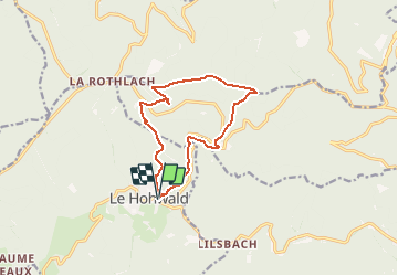
Le Hohwald - Chemin des Bornes - Neuntelstein

patrickbeyrath
User

Length
11.3 km

Max alt
981 m

Uphill gradient
440 m
Km-Effort
17.2 km

Min alt
572 m

Downhill gradient
441 m
Boucle
Yes
Creation date :
2019-08-23 05:53:18.751
Updated on :
2019-08-23 06:01:31.749
3h33
Difficulty : Medium

FREE GPS app for hiking
 SityTrail
IGN / Geographical institutes
SityTrail Plus
The world is yours!
About
Trail Walking of 11.3 km to be discovered at Grand Est, Bas-Rhin, Le Hohwald. This trail is proposed by patrickbeyrath.
Description
Départ du parking près du camping - GR5 Welschbruch puis Carrefour du Neugruenrain - Chemin des Bornes - Neuntelstein et retour par triangle jaune, losange rouge puis rond jaune
Positioning
Country:
France
Region :
Grand Est
Department/Province :
Bas-Rhin
Municipality :
Le Hohwald
Location:
Unknown
Start:(Dec)
Start:(UTM)
376404 ; 5362515 (32U) N.
Comments